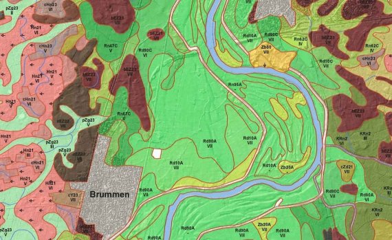
A fragment of the soil map of the Netherlands. © Wageningen Environmental Research
Last year, the soil map and geomorphological map of the Netherlands were put online with free access. Now Wageningen Environmental Research has added the soil profiles as well. That means all Wageningen’s soil data has been made available. This puts into effect the Subsurface Key Register Act (BRO) from 2015.
Edelman drill
The database contains a total of around 330,000 soil profiles obtained from drilling. This collection has been built up over decades, explains soil scientist Joop Okx. ‘The programme started in 1960. The Netherlands’ first soil map was completed 30 years later.’ Drilling was (and still is) a manual task, using the Edelman drill named after former Wageningen professor Cees Edelman.

Drills have now been sunk up to 1.5 metres into the ground over 330,000 times. That is more than 400 kilometres of soil profiles, according to Okx’s calculations.
Measuring started again in 2009. The soil is not a static entity, says Okx. ‘The drilling programme focuses on areas where we expect changes. Peatland, for example. Peat shrinks due to oxidation. And soil levels in the polders can sometimes fall considerably due to draining. We are currently working on the Flevopolder, where ground levels have fallen by as much as 1.6 metres in extreme parts of Almere.’
Gound levels have fallen by as much as 1.6 metres in extreme parts of Almere.
Joop Okx
A couple of thousand holes are drilled every year. Models are used to combine that drilling data with satellite information and current heights to create up-to-date soil maps. The maps and data are available on the BRO site and that of PDOK (the Dutch national spatial data infrastructure).